
Ha Giang Travel Guide

Ha Giang is Vietnam’s last great frontier — a remote northern province bordering China where the Dong Van Karst Plateau rises into a landscape of buckwheat fields, H’mong villages, and mountain roads so dramatic they’ve been called the most beautiful in Southeast Asia. Fewer tourists reach Ha Giang than anywhere else in northern Vietnam, and that is precisely the point. For travelers who have done Sapa and Ha Long Bay and want something rawer, harder, and more unforgettable — this is where the road leads.
This guide covers everything: the Ha Giang Loop route, how to ride it, the Dong Van Karst Plateau UNESCO sites, the best time to visit, how to get there from Hanoi, and the specific local knowledge that makes the difference between a dangerous trip and a transcendent one.
Jump to: Why Ha Giang · The Ha Giang Loop · Things to Do · Motorbike vs Easy Rider · Best Time to Visit · Getting There · Where to Stay · 4-Day Itinerary · Travel Tips · FAQ
Ha Giang at a Glance


| Quick Fact | Details |
|---|---|
| Location | Northernmost province of Vietnam — borders Yunnan Province, China |
| Distance from Hanoi | ~320 km / 5–6 hrs by bus or private car |
| UNESCO Status | Dong Van Karst Plateau Geopark — UNESCO Global Geopark since 2010 |
| The Loop | ~350 km circuit through Dong Van, Meo Vac, Yen Minh — typically 3–4 days |
| Best Time to Visit | October (buckwheat flowers) · September (rice harvest) · March–April (rapeseed flowers) |
| Recommended Stay | 4 days minimum for the full Loop; 3 days possible but rushed |
| Main Ethnic Groups | H’mong (dominant), Lo Lo, Tay, Nung, Giay, Dao — 19 ethnic groups in the province |
| Key Highlights | Ma Pi Leng Pass, Dong Van Old Quarter, Lung Cu Flag Tower, Meo Vac market, buckwheat fields |
| Permit Required | Yes — foreigners need a permit to access some border zones. Obtainable in Ha Giang City (~30 min). |
| Riding Options | Self-ride (semi-automatic motorbike) · Easy Rider (local driver-guide) · Minibus tours |
Why Ha Giang — An Honest Local Perspective
Ha Giang doesn’t offer comfort. The roads are steep and winding, the accommodation in remote villages is basic, and the distances between points of interest are long. If you come expecting Sapa’s infrastructure or Ha Long Bay’s polished cruise experience, you will be disappointed — and possibly in danger on a motorbike.
What Ha Giang offers instead is something most of Vietnam’s tourist circuit has lost: genuine remoteness. A landscape so extreme it barely feels like the same country as Hanoi’s Old Quarter. Villages where the H’mong and Lo Lo communities have maintained their architecture, agricultural practices, and cultural identity not as a performance for visitors but because the terrain itself kept the outside world at bay for centuries. Roads that wind along cliff edges above 1,000-metre drops with not another tourist in sight. And in October, buckwheat fields blooming pink and white across the karst plateau in a display of colour that has no equivalent anywhere else in Vietnam.
Here’s what genuinely sets Ha Giang apart:
- The Dong Van Karst Plateau is geologically extraordinary. Vietnam’s only UNESCO Global Geopark covers 2,356 km² of ancient rock formations — some over 500 million years old — creating a landscape of grey limestone peaks, narrow river gorges, and vertical cliff faces that overwhelms on a scale that photographs cannot convey.
- Ma Pi Leng Pass is the most dramatic road in Vietnam. The 20 km mountain pass between Dong Van and Meo Vac — cut into a vertical cliff face above the Nho Que River 1,000 metres below — is considered the most spectacular road in Southeast Asia by most who have ridden it. There is nothing comparable in Vietnam.
- The ethnic diversity is unmatched. Ha Giang Province has 19 officially recognised ethnic minority groups. The H’mong architecture, Lo Lo textile traditions, and the Sunday markets at Dong Van and Meo Vac draw communities from across the plateau in traditional dress for weekly trade — not for tourists, but for each other.
- Seasonal flowers transform the plateau. Three distinct flower seasons — pink buckwheat (late October–November), yellow rapeseed (March–April), and white tam giac mach in some valleys (October) — make the timing of a Ha Giang trip matter in a way unlike any other Vietnamese destination. The buckwheat season in particular brings some of the most remarkable natural colour displays in Asia.
- It is genuinely off the mass-tourism circuit. Ha Giang receives a fraction of the international tourists that Sapa or Ha Long Bay sees. The roads, villages, and mountain passes still feel discovered rather than managed. This will change — it is already changing — which is a reason to go now rather than later.

The Ha Giang Loop: Everything You Need to Know
The Ha Giang Loop is a ~350 km circuit road that forms the backbone of any Ha Giang trip. Starting and ending in Ha Giang City, it passes through the most dramatic sections of the Dong Van Karst Plateau — ascending from river valleys into high mountain terrain, crossing Ma Pi Leng Pass, reaching the Chinese border at Lung Cu, and returning through a different set of valleys and villages. Most travelers complete it in 3–4 days.
The Classic Loop Route
| Day | Route | Distance | Key Stops |
|---|---|---|---|
| Day 1 | Ha Giang City → Quan Ba → Yen Minh → Dong Van | ~145 km | Quan Ba Heaven’s Gate (Cong Troi), Twin Mountains (Nui Doi), Yen Minh pine forest, Dong Van Old Quarter arrival at dusk |
| Day 2 | Dong Van → Lung Cu → Meo Vac | ~90 km | Dong Van Old Quarter morning, Lung Cu Flag Tower (Vietnam’s northernmost point), Ma Pi Leng Pass, Nho Que River viewpoint, Meo Vac town |
| Day 3 | Meo Vac → Du Gia → Bac Me | ~100 km | Nho Que River boat trip (optional), Du Gia village, Nho Que River valley descent, Bac Me overnight |
| Day 4 | Bac Me → Ha Giang City | ~60 km | Bac Me market (if Sunday), Mien River valley, return to Ha Giang City for bus back to Hanoi |

Extended Loop options: Many experienced riders add a 5th day to explore secondary roads — the Sung La valley (site of the famous H’mong king’s palace, Vuong Palace), the high road above Dong Van toward Pho Cao, or a morning boat ride on the Nho Que River at sunrise. The Loop is a framework, not a fixed itinerary — the best Ha Giang experiences usually happen when you stop the bike and stay somewhere longer than planned.
Clockwise vs Counter-Clockwise
Most guides recommend riding the Loop clockwise (Ha Giang → Quan Ba → Dong Van → Meo Vac). This puts the most dramatic section — Ma Pi Leng Pass — on Day 2 when you’re settled into the riding and not fatigued. Counter-clockwise is quieter on the roads but means tackling the hardest terrain on Day 1. Clockwise is the consensus recommendation.
Not sure whether to self-ride the Loop or use an Easy Rider guide? Our Hanoi-based team arranges Ha Giang Loop tours with experienced local driver-guides — we’ll match you with the right option for your riding experience and travel style. Message us on WhatsApp →
Best Things to Do in Ha Giang
1. Ride Ma Pi Leng Pass
The 20 km pass between Dong Van and Meo Vac is cut directly into a vertical cliff face, with the Nho Que River running 1,000 metres below in an impossibly deep gorge. The road narrows to single-vehicle width in places, the drops are unguarded, and the views of the river, a thread of turquoise between grey karst walls, are among the most overwhelming in Asia. There is a dedicated viewpoint roughly halfway where most riders stop; the panorama of the gorge from here justifies the entire journey to Ha Giang. Ride slowly. Photograph constantly. This is the moment.

Hanoi Old Quarter
The Heart of Hanoi
2. Dong Van Old Quarter at Dawn
Dong Van’s old quarter — a cluster of traditional H’mong and Chinese-influenced stone houses dating to the early 20th century — is one of the best-preserved historic settlements in northern Vietnam. Arriving late afternoon on Day 1 and walking the quarter at dawn on Day 2 (before the day-trippers from closer guesthouses arrive) reveals a working community: smoke from kitchen fires, children heading to school, elderly H’mong women in traditional dress carrying produce to the morning market. The Sunday market here draws communities from a 30 km radius.

Hoan Kiem Lake
Central Lake in the Heart of Hanoi
3. Lung Cu Flag Tower — Vietnam’s Northernmost Point
The Lung Cu Flag Tower stands at Vietnam’s northernmost geographic point, on Dragon Mountain at 1,700 metres, with China literally visible across the valley. The climb to the tower (250 steps) passes H’mong and Lo Lo villages whose houses straddle the national boundary. The symbolism — the Vietnamese flag flying at the absolute edge of the country, above communities that predate the concept of that border — is genuinely moving. A 30-minute detour from the Dong Van–Meo Vac road that most Loop riders consider essential.

Temple of Literature
The First University in Vietnam
4. Buckwheat Flower Fields (Late October–November)
The buckwheat (Tam Giac Mach) bloom across the Dong Van Karst Plateau is Ha Giang’s most extraordinary seasonal event — pink and white flowers covering the hillsides between karst peaks, filling valley floors, running alongside roads for kilometres. It is the single most visually dramatic seasonal display in northern Vietnam, and the reason many travelers plan their entire trip around the October–November window. The fields around Lung Cu, Pho Cao, and the slopes above Sung La valley are the most concentrated; your Easy Rider guide will know the peak locations in any given year.

Ho Chi Minh Mausoleum
A Final Rest of National Hero
5. Nho Que River Boat Trip
The Nho Que River at the base of Ma Pi Leng gorge — accessible by boat from Meo Vac or the landing point below the pass — offers a completely different perspective on the gorge: looking up at 1,000-metre cliff walls from water level, with the turquoise river (the colour comes from mineral deposits upstream) reflecting the karst above. Boat trips run from the landing approximately 7 km up the gorge; 2-hour round trips cost around 150,000–200,000 VND per person. Best in morning light.

Water Puppet Show
A Must-See in Hanoi
6. Vuong Palace (H’mong King’s Palace) in Sung La
The former residence of Vuong Chi Sinh — the H’mong opium king who effectively ruled the Dong Van plateau in the early 20th century — is a remarkable structure: a blend of H’mong, Chinese, and French colonial architecture built from 1919 to 1928 using stone quarried from the surrounding karst. The palace and its history (the opium trade, the alliance with French colonial authorities, the eventual handover to the Vietnamese government) is a story that illuminates the entire plateau’s complex history. Located in Sung La valley, 10 km off the main Loop road.

Vietnamese Banh Mi
A Must-Try in Hanoi
7. Meo Vac Sunday Market
The Sunday market at Meo Vac — the largest and most traditional ethnic minority market on the Loop — draws H’mong, Lo Lo, Giay, and Nung communities from across the plateau, many having walked several hours to reach it. The market trades in livestock (horses, pigs, cattle), agricultural produce, tools, textiles, and medicinal herbs. It is a functional trade market, not a tourist destination — which is precisely why it remains extraordinary. Arrive by 7 AM. The livestock section closes by 9 AM.
Vietnamese Banh Mi
A Must-Try in Hanoi
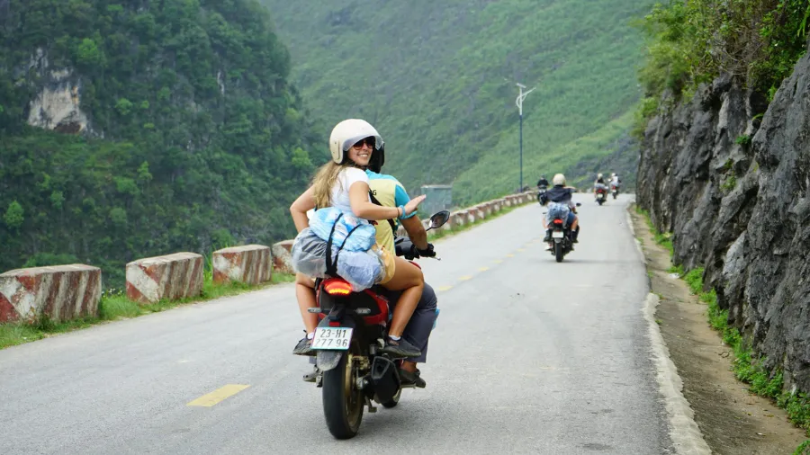
Self-Ride vs Easy Rider: Which Option Is Right for You?


This is the most consequential decision you’ll make about your Ha Giang trip — and the one most travelers don’t research carefully enough. The roads are genuinely dangerous for inexperienced riders. Here is the honest breakdown:
| Criteria | Self-Ride (Semi-Automatic) | Easy Rider (Local Driver-Guide) | Minibus/Jeep Tour |
|---|---|---|---|
| Freedom | Maximum — stop anywhere, anytime | High — guide follows your pace and interests | Low — fixed schedule and stops |
| Safety | Highest risk — requires genuine riding experience | Lower risk — experienced local driver handles roads | Lowest risk — professional driver, enclosed vehicle |
| Cultural access | Limited — language barrier without guide | Excellent — guide provides village introductions, language, context | Moderate — depends on guide quality |
| Cost | $8–$15/day (bike rental) + fuel | $35–$60/day (driver-guide + bike, per person) | $60–$120/day pp (all-inclusive group tour) |
| Best for | Experienced riders with 2+ years motorbike experience, comfortable with mountain roads | Most travelers — the best balance of experience, safety, and cultural depth | Non-riders, older travelers, those prioritising comfort over adventure |
| Road experience required | Essential — Ha Giang roads are not beginner terrain | None — you ride pillion on your guide’s bike | None |
Our honest recommendation: The Easy Rider option is the right choice for the majority of travelers, including most people who consider themselves “reasonably experienced” riders. The Ha Giang Loop roads — steep gradients, loose gravel sections, sharp blind hairpins, no guard rails above 500m drops — are significantly harder than they appear in videos. An experienced local Easy Rider guide provides both physical safety and cultural access that transforms the trip. Self-riding is genuinely rewarding for those qualified for it; be honest with yourself about whether you are.
If you self-ride: Rent from a reputable Ha Giang City shop (not the cheapest option), take a semi-automatic Honda Win or XR150 rather than a manual bike if you’re less experienced, carry a basic tool kit and puncture repair kit, and never ride after dark on the Loop roads.
Best Time to Visit Ha Giang: Month-by-Month Guide


Ha Giang is one of Vietnam’s most season-sensitive destinations. The landscape transforms dramatically across the year — three distinct flower seasons, a rice harvest, and a winter that closes some high passes. Timing your visit correctly can be the difference between a good trip and a once-in-a-lifetime one.
| Period | Conditions | Landscape | Verdict |
|---|---|---|---|
| Jan – Feb | Cold (0–12°C at altitude), fog, occasional frost. Some high passes may be icy. | Bare terraces, occasional snow on peaks above 1,800 m | Not recommended for most travelers. Beautiful if you embrace cold and fog. Tet period (Jan/Feb) brings domestic visitors to markets — culturally interesting but logistically challenging. |
| Mar – Apr ⭐ | Warming (12–22°C), clearer skies, spring conditions | Yellow rapeseed (cai vang) bloom — valley floors turn gold | Excellent. Rapeseed fields in Quan Ba and Yen Minh valleys bloom brilliant yellow. Clear visibility for Ma Pi Leng views. Good roads, manageable crowds. One of the two best windows. |
| May – Jun | Warming to hot (20–30°C), increasing rain | Rice planting season — terraces flooded, mirror-like | Good for flooded terrace photography. Rain begins in earnest from late May — roads can develop mudslides. Fewer tourists than peak seasons. |
| Jul – Aug | Warm and wet — heaviest rain of the year | Vivid green rice, but heavy cloud coverage | Significant landslide and road closure risk after heavy rain. Not recommended unless prepared for weather disruption. Views frequently obscured. Green terraces are beautiful when visible. |
| Sep ⭐ | Clearing fast (20–28°C), post-rain freshness | Golden rice harvest — terraces turn amber on hillsides | Excellent. The golden rice harvest arrives in late September — particularly striking in the Hoang Su Phi terraces (west Ha Giang, a separate destination worth adding). Clear skies returning. Roads usually clear of rain damage. |
| Oct – Nov ⭐⭐ | Cool and clear (15–25°C) — best weather of the year | Pink buckwheat bloom (late Oct–Nov) — the most spectacular display | Peak season — the best window overall. Buckwheat flowers cover the plateau pink and white. Perfect riding weather. Clearest visibility for Ma Pi Leng views. Book accommodation 4–6 weeks ahead for Dong Van and Meo Vac. This is Ha Giang at its absolute best. |
| Dec | Cold (8–18°C), increasingly foggy | Post-harvest, brown terraces, atmospheric mist | Acceptable for experienced travelers who appreciate solitude and atmospheric conditions. Fewer tourists. Dress very warmly — dawn temperatures at 1,600 m are genuinely cold. Some passes may be foggy enough to slow riding significantly. |
Note on Hoang Su Phi: The western section of Ha Giang Province — around Hoang Su Phi and Xin Man — holds some of northern Vietnam’s most extraordinary layered rice terraces, at a different elevation and timing to the Loop. The harvest here peaks in late September to early October, slightly before the Loop’s buckwheat season. Adding 1–2 days in Hoang Su Phi to a Ha Giang trip creates a 6–7 day highland circuit that covers both the Loop and one of Vietnam’s most photogenic terrace landscapes.
How to Get from Hanoi to Ha Giang

| Transport | Duration | Cost (approx.) | Best For |
|---|---|---|---|
| Overnight sleeper bus (Hanoi → Ha Giang City) | 6–7 hrs | $10–$18 pp | Most travelers — depart Hanoi 9–10 PM, arrive Ha Giang City 4–5 AM (early enough to get the Loop permit and start riding by 8 AM). Operators: Hung Thanh, Ha Giang Bus. Book through Vexere.com or your Hanoi guesthouse. |
| Private car (Hanoi → Ha Giang City) | 5–6 hrs (daytime) | $90–$130 (whole car) | Groups of 3–4, families, or travelers who prefer daytime scenic driving. The road from Hanoi passes through Tuyen Quang and offers its own mountain scenery from around the 3-hour mark. |
| Public bus (Hanoi My Dinh → Ha Giang) | 6–7 hrs | $6–$10 pp | Budget independent travelers. Several departures daily from Hanoi’s My Dinh bus station. Slower and less comfortable than the sleeper bus but the cheapest option. |
The Loop permit: Foreign travelers must obtain a permit to access the Dong Van Karst Plateau border zone. The permit is processed at the Ha Giang City police station or through a registered tour operator — it takes approximately 30 minutes and costs a nominal fee (~$2). Your guesthouse or Easy Rider guide in Ha Giang City will handle this if you arrive by overnight bus. It cannot be obtained in Hanoi in advance.
Where to Stay on the Ha Giang Loop
| Location | Best For | Vibe | Average Price (per night) |
|---|---|---|---|
| Ha Giang City | First night, permit processing, bike rental | Provincial town — practical, not scenic. Good guesthouses on Tran Hung Dao Street. | $8–$30 |
| Dong Van Town | Loop Day 1 overnight — the most atmospheric stop | Old quarter stone houses, H’mong market town feel, excellent position for dawn exploration before Day 2 ride | $10–$45 |
| Meo Vac Town | Loop Day 2 overnight — after Ma Pi Leng | Smaller and more local feeling than Dong Van. Sunday market location. Fewer guesthouses — book ahead in October. | $8–$35 |
| Du Gia / Bac Me (villages) | Loop Day 3 overnight — off-the-beaten-path | Remote riverside homestays, almost no other tourists, communal meals with H’mong or Tay families | $5–$15 |
| Sung La Valley homestays | Buckwheat season, photography focus | Valley homestays surrounded by buckwheat fields — the best base for early morning photography in October–November | $8–$20 |
Booking in October–November: Dong Van and Meo Vac guesthouses sell out weeks in advance during buckwheat season. Book as early as possible — 4–6 weeks ahead for accommodation on the Loop during peak flower season. Your Easy Rider guide or Ha Giang tour operator can handle bookings as part of a package.
3-Day Sapa Itinerary: The Best Structure for First-Time Visitors
4-Day Ha Giang Loop Itinerary – Ultimate Northern Vietnam Adventure. Ride through the legendary Ha Giang Loop, conquering epic passes like Ma Pi Leng Pass and exploring the stunning Dong Van Karst Plateau. A 4-day journey of dramatic landscapes, ethnic culture, and unforgettable road-trip moments—book now for the real Ha Giang experience.


Day 1: Ha Giang City → Quan Ba → Yen Minh → Dong Van (~145 km)
- Arrive Ha Giang City by overnight bus (~5 AM). Check into guesthouse, rest 2 hours.
- 7:30 AM: Obtain Loop permit (your guesthouse or Easy Rider guide arranges — 30 min). Collect rental bike or meet Easy Rider guide.
- 8:30 AM: Depart Ha Giang City. First major stop: Quan Ba Heaven’s Gate (Cong Troi) — a mountain pass viewpoint over the Twin Mountains (Nui Doi) and the valley below. Allow 30–45 minutes.
- Late morning: Continue through Yen Minh — a small town with pine forests atypical for the region. Lunch here or continue to Pho Bang village (off-route but worth it for the H’mong stone house architecture).
- Afternoon: The landscape shifts dramatically from here — karst peaks become more severe, valleys narrower. First views of the Dong Van Plateau character.
- 5:00–5:30 PM: Arrive Dong Van Town. Check in. Walk the old quarter at dusk — the evening light on the stone facades is exceptional.
- Evening: Dinner in Dong Van. Try men men (H’mong corn porridge — the staple highland food), grilled pork with local herbs, and ruou ngo (corn wine — potent, distinctive, locally made).
- Overnight in Dong Van
- Day 1 tip: The 145 km from Ha Giang City to Dong Van is the longest day on the Loop. Resist the temptation to rush — there are 15–20 stopping points worth time. Leave by 8:30 AM at the latest.
Day 2: Dong Van → Lung Cu → Ma Pi Leng → Meo Vac (~90 km)
- 6:00 AM: Dawn in Dong Van Old Quarter. Before the market opens and the day begins. Walk the stone lanes alone — the most atmospheric 45 minutes of the Loop.
- 7:30 AM: Dong Van Sunday Market (if applicable — worth adjusting your Loop timing to arrive Dong Van on a Saturday evening).
- 9:00 AM: Depart for Lung Cu Flag Tower (~23 km north, 45-min detour from the main road). Climb to Vietnam’s northernmost point. China visible across the valley. Allow 60–75 minutes.
- 11:00 AM: Return to main road. Begin approach to Ma Pi Leng Pass.
- 12:00–1:00 PM: Ma Pi Leng Pass. Ride the 20 km cliff-face road above the Nho Que gorge. Stop at the main viewpoint (roughly halfway) for the full panorama. Do not rush this section — the road demands attention and the scenery rewards it.
- 2:00 PM: Descend to Meo Vac Town. Late lunch. Check in.
- 3:30 PM: Nho Que River boat trip from the landing below Meo Vac — 2-hour gorge exploration from water level. Book through your guesthouse on arrival.
- Evening: Meo Vac is smaller and quieter than Dong Van. Dinner at a local restaurant. Early night — Day 3 road is long.
- Overnight in Meo Vac
- Ma Pi Leng tip: The pass road is single-vehicle width in several sections with no guard rails. Oncoming traffic exists. Ride at 20–30 km/h maximum, use your horn on blind corners, and never overtake on the cliff-edge sections.
Day 3: Meo Vac → Du Gia → Bac Me (~100 km)
- 7:00 AM: Depart Meo Vac. The road south from Meo Vac descends steadily from the high plateau — scenery transitions from karst to river valley, from stone houses to bamboo.
- Mid-morning: Optional stop at Khau Vai Love Market site (27 km from Meo Vac) — a village where an annual market with deep romantic cultural significance takes place (one day per year in late April); the village itself is worth a stop for Lo Lo architecture.
- Late morning: Du Gia village — a Tay and H’mong community on the Mien River. One of the most photogenic village settings on the return loop. Wooden stilt houses, river reflections, karst backdrop.
- Lunch in Du Gia or a roadside stop. Freshwater fish from the Mien River.
- Afternoon: Continue to Bac Me. The landscape here is softer and greener than the high plateau — a marked contrast that makes the descent feel like re-entering a different country.
- Evening: Overnight homestay in Bac Me or a nearby village. Communal dinner with host family.
- Overnight in Bac Me or Du Gia homestay
Day 4: Bac Me → Ha Giang City → Bus to Hanoi (~60 km + overnight bus)
- 7:00 AM: Final morning on the road. The last 60 km from Bac Me to Ha Giang City follows the Gam River — wide, calm, and lined with rice fields. A quiet end to an intense few days.
- 9:30 AM: Arrive Ha Giang City. Return rental bike (if self-riding). Settle with Easy Rider guide.
- 10:00 AM–4:00 PM: Free time in Ha Giang City. Rest, eat, walk the riverside market. Ha Giang City itself is unremarkable but the food is good — try pho ga Ha Giang (local chicken pho, noticeably different from Hanoi’s version).
- 4:00 PM: Buy bus ticket for Hanoi departure (evening buses 6–8 PM, arrive Hanoi 1–3 AM) or book an extra night in Ha Giang City and take the morning bus for a more comfortable return.
- Evening: Overnight bus back to Hanoi.
- Overnight bus / Hanoi arrival
- Return tip: If your schedule allows, take the 6 AM bus rather than the overnight return — the daytime Hanoi–Ha Giang road (in reverse) passes through mountain scenery that the dark obscures on the outbound overnight journey.
Want the Ha Giang Loop Arranged Without the Stress?
Our Hanoi-based team handles Ha Giang Loop logistics from end to end — overnight bus, permit, matched Easy Rider guide, accommodation bookings in Dong Van and Meo Vac, and a return that fits your onward schedule. For October buckwheat season, we recommend booking 6–8 weeks ahead.
Request Your Free Ha Giang Itinerary →
Tell us your travel dates, riding experience, and whether you want self-ride or Easy Rider. We’ll send you options within 4 hours.
Sale!

Authentic Hanoi Day Tour | Incense Village & Duong Lam Ancient Village

Place
Hanoi

Duration
1D
Original price was: 120$.105$Current price is: 105$.
Sale!
Hanoi Cycling Tour | Bat Trang, Kim Lan & Xuan Quan Flower Villages
Place
Bat Trang
Duration
1D
Original price was: 65$.55$Current price is: 55$.
Sale!

Half-Day Hanoi City Tour | Explore Iconic Landmarks in Just Few Hours
Place
Ha Noi
Duration
1D
Original price was: 50$.35$Current price is: 35$.
Sale!

Exclusive Hanoi Street Food Tour | Discover Hanoi’s Best Eats on Foot
Place
Ha Noi
Duration
1D
Original price was: 50$.35$Current price is: 35$.
Sale!

Hanoi City Tour | Highlights, Local Culture | Best of Hanoi in One Day
Place
Ha Noi
Duration
1D
Original price was: 55$.45$Current price is: 45$.
Sale!

Top Hanoi City Walking Tour | Discover the Best of Hanoi in One Day
Place
Hanoi Capital City
Duration
1D
Original price was: 60$.50$Current price is: 50$.
Sale!

Incense Village Hanoi Tour | Explore Traditional Craft & Local Culture
Place
Quang Phu Cau
Duration
1D
Original price was: 85$.55$Current price is: 55$.
Sale!

Private Mai Chau Day Trip And Waterfall & Hot Spring Bath
Place
Mai Chau
Duration
1D
Original price was: 175$.125$Current price is: 125$.
Beyond the Loop: Less-Known Ha Giang Experiences
- Ha Giang vs Sapa — the traveler’s dilemma: Experienced Vietnam travelers often debate which is better. Sapa is more accessible and has better infrastructure; Ha Giang’s Dong Van Karst Plateau is rawer, more remote, and arguably more visually dramatic for landscape photography. If you have 4–5 days in northern Vietnam’s highlands, Ha Giang Loop (motorcycle circuit, 3–4 days) is worth considering alongside or instead of Sapa.

- The Saturday night Love Market tradition: Historically, Sapa’s Saturday market was a place where young H’mong people from different villages came to meet potential partners — dressed in their finest traditional clothing, singing and playing the traditional H’mong flute (ken). The tradition is more muted now than decades past, but on Saturday evenings the market atmosphere and traditional dress are still markedly different from weekday visits.
- Cooking class with a H’mong host family: Several Sapa operators offer cooking sessions hosted in H’mong family homes — preparing traditional dishes using foraged mountain herbs, bamboo shoots, and locally grown produce over open wood fires. Different in character from city cooking classes; genuinely domestic and illuminating about highland food culture.
- The Tram Ton Pass viewpoint at dawn: The mountain pass at 1,900 metres between Sapa and Lai Chau — 15 km from Sapa Town — is the highest road pass in Vietnam. At dawn on a clear day, you’re above the cloud layer looking down over valleys filled with white mist with peaks emerging above. A 30-minute motorbike or taxi ride from Sapa Town; best experienced before 7 AM.
- Nam Cang overnight trek: The Nam Cang – Nam Sai route reaches Giay and H’mong villages that see perhaps 5–10 international visitors per week. No souvenir stalls, no guesthouses designed for tourists — just working villages accessible to those willing to walk 2 days and stay in family homes. Arrange through a specialist local operator at least 2–3 days in advance.
Essential Sapa Travel Tips (From Our Local Team)
- Pack for four seasons in three days. Sapa’s weather can shift from warm sunshine to cold fog within hours, and temperatures drop significantly after dark year-round. Bring: a warm waterproof jacket, a mid-layer fleece, moisture-wicking base layers, and good trekking shoes with ankle support. Even in September, evenings in Sapa Town can drop to 15°C.
- Book the overnight train at least 2–3 weeks ahead in September–October. Soft sleeper 4-bed cabins on the Hanoi–Lao Cai line sell out weeks in advance during harvest season. Book through a reputable Hanoi operator or directly through the Vietnam Railways website (vexere.com works well for online booking).
- Choose a local ethnic minority guide, not a city-based guide. The difference between a Hanoi-trained tour guide and a female H’mong or Red Dao guide from the villages you visit is fundamental. Local guides provide cultural access, language interpretation, and personal relationships with village families that no outsider can replicate. Several Sapa operators — Sapa O’Chau and Ethos Spirit are well-regarded — specifically employ and train local community guides.
- Don’t photograph villagers without asking. The H’mong and Red Dao communities are not subjects — they’re people going about their lives. Ask permission (your guide will help). Offer to show people the photo afterward. Put the camera away when it’s clearly not wanted. This basic courtesy transforms how villagers respond to your presence throughout the day.
- Check Fansipan summit conditions before buying cable car tickets. The 3,143 m summit is cloud-covered a significant proportion of the time — even on otherwise good-weather days. Ask your hotel or a local guide for the morning weather report before committing to the cable car. Midday (10 AM–12 PM) tends to have the best summit clarity on fine days.
- Gaiters for jungle trails in summer. Leeches are active on Sapa’s forest trails from June through September. They’re harmless but unpleasant. Lightweight gaiters or leech socks (available cheaply in Sapa Town) solve the problem entirely. Salt or insect repellent also works as a deterrent.
- Sapa Town shopping tip: The best quality H’mong textiles are found at the Women’s Cooperative market near the town square — hand-embroidered fabrics, indigo-dyed clothing, and silver jewellery made by the sellers themselves. The quality and authenticity here is significantly higher than the stalls near tourist hotels, and buying directly from makers is the right economic choice.


Frequently Asked Questions — Sapa Travel Guide
Is Sapa worth visiting?
Yes — despite increased commercialisation in the town itself, Sapa’s surrounding valleys, trekking routes, and ethnic minority communities remain genuinely extraordinary. The Muong Hoa Valley rice terraces are among the most beautiful landscapes in Southeast Asia, and the H’mong and Red Dao cultures are distinct in ways that reward attentive visitors. The key is choosing the right trekking route, a local guide, and if possible staying overnight in a valley homestay rather than only in Sapa Town.
How many days do I need in Sapa?
Three days is the recommended minimum for a first-time Sapa visit — enough for the Muong Hoa Valley trek, Ta Phin village, and Fansipan cable car. Two days is possible but rushed. Four to five days allows for the full Fansipan summit trek, a multi-valley circuit, and a genuine overnight homestay experience in a remote village. Budget travelers doing northern Vietnam on a circuit often combine Sapa (3 nights) with Ha Giang Loop (3–4 nights) for a comprehensive highland experience.
When is the best time to visit Sapa?
The best time to visit Sapa is September and October, when the rice harvest turns the terraces gold and skies are at their clearest — the peak season for good reason. March to May is the second-best window: spring flooding of terraces creates mirror-like reflections, and wildflowers bloom on Fansipan slopes. Avoid December and January if clear views matter — fog and cold are frequent. All seasons have value, but harvest season (late September–mid-October) is consistently the most photographically rewarding.
How do I get from Hanoi to Sapa?
The most practical route is the overnight sleeper train from Hanoi to Lao Cai station (8–9 hours), followed by a 45-minute taxi or minibus to Sapa Town. Book a soft sleeper 4-bed cabin ($25–$40) for comfort — depart Hanoi around 9–10 PM, arrive Lao Cai at 6 AM, and reach Sapa by 7:30 AM with a full day ahead. Direct express buses from Hanoi Old Quarter (5–6 hrs, $12–$20) are a faster and slightly cheaper alternative.
Do I need a guide for trekking in Sapa?
For most Sapa routes, a licensed local guide is required by regulation — trekking permits for areas outside Sapa Town specify guided access. Beyond the regulatory requirement, a local ethnic minority guide — ideally from the H’mong or Red Dao community — is genuinely invaluable. They provide cultural interpretation, village access, language translation, and a relationship with local families that transforms the experience from scenic walking to genuine cultural encounter. Choose guides trained and employed from local communities where possible.
What is the best trekking route in Sapa for first-time visitors?
The Muong Hoa Valley route from Sapa Town through Lao Chai to Ta Van is the best single Sapa trek for first-time visitors. It covers 15 km over 6–7 hours, passes through both H’mong and Giay ethnic minority villages, runs along the Muong Hoa River with continuous rice terrace scenery, and suits moderate fitness levels. It can be done as a day trek with vehicle pickup at Ta Van or extended into an overnight homestay in the valley.
Is Sapa or Ha Giang better for trekking?
They offer genuinely different experiences. Sapa has better infrastructure, shorter transit from Hanoi, more trekking route variety at different difficulty levels, and the most striking rice terrace scenery in Vietnam. Ha Giang — specifically the Dong Van Karst Plateau and the Ha Giang Loop — is rawer, more remote, more dramatic for road and mountain scenery, and sees significantly fewer tourists. For first-time visitors to highland Vietnam, Sapa is the more accessible introduction; experienced travelers who return to the north often rate Ha Giang as the more memorable experience.
What food is Sapa famous for?
Sapa’s highland food is distinct from lowland Vietnamese cuisine. Key dishes: com lam (sticky rice cooked inside bamboo tubes over open fire — fragrant and smoky), thang co (H’mong horse or buffalo stew with organs and mountain spices — the most culturally specific dish, best tried at the market), grilled stream fish (ca suoi — freshwater fish from mountain streams, grilled with lemongrass and ginger), and black cardamom pork (a Red Dao specialty using locally grown cardamom). The Sapa market is the best place to eat all four.

Plan Your Sapa Trip with a Local Expert
We’re a Hanoi-based travel company with deep connections to the Sapa trekking community — including local H’mong and Red Dao guides who’ve been leading routes in the Muong Hoa Valley and beyond for over a decade. When you plan with us, you get the right guide for your group, honest advice on route selection for your fitness level, and an itinerary that actually reaches the parts of Sapa most visitors miss.
- Private Sapa treks with local ethnic minority guides
- Overnight train and valley homestay packages from Hanoi
- Fansipan summit treks (2-day hiking route, not just cable car)
- Combined Hanoi + Sapa + Ha Giang itineraries for highland circuits
- Available 7 days a week — respond within 2–4 hours on WhatsApp
Get Your Free Sapa Trip Plan
Tell us your travel dates, group size, fitness level, and what matters most — rice terrace photography, cultural encounters, summit trekking, or a mix of all three. We’ll send you a suggested itinerary with transparent pricing within 4 hours.
Request Your Free Sapa Itinerary →
Or message us directly on WhatsApp: +84 849 391 981
Explore More Northern Vietnam
- Hanoi Travel Guide — the best base for your northern Vietnam trip
- Ha Giang Travel Guide — the Dong Van Karst Loop, Vietnam’s most dramatic highland road
- Ha Long Bay Travel Guide — combine highland Sapa with a coastal cruise
- Ninh Binh Travel Guide — UNESCO karst landscape 2 hours south of Hanoi
- 7-Day Northern Vietnam Itinerary — Hanoi + Sapa + Ha Long Bay
- 10-Day Northern Vietnam Itinerary — add Ha Giang Loop and Ninh Binh
- Browse Sapa Trekking Tours →